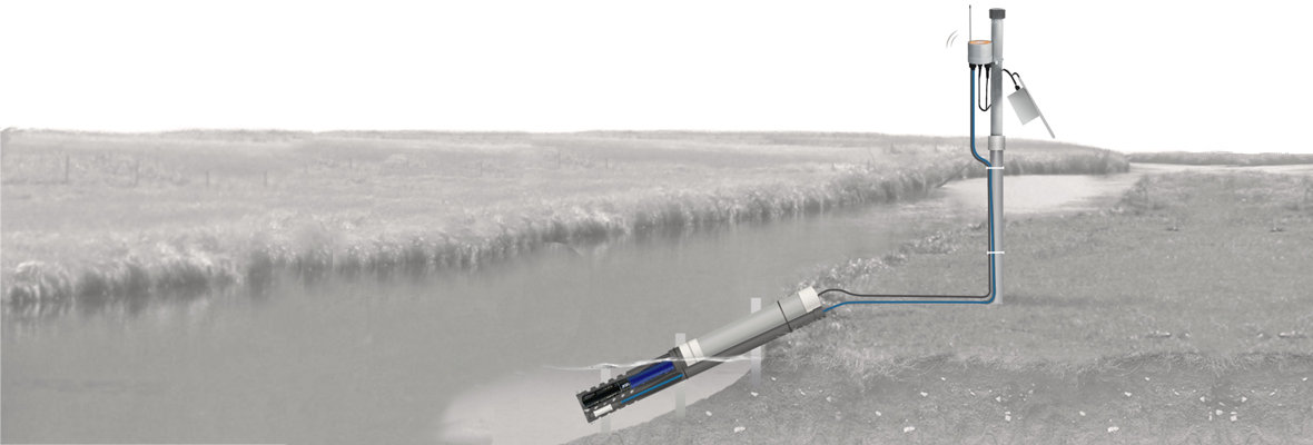
When it comes to monitoring the water quality of streams and rivers, in many ways the work is similar to other bodies of freshwater. Many of the parameters remain the same, whether you’re pursuing a research application or a practical objective. However, streams and rivers have one quality that sets them apart: movement.
Being in motion means that stream and river monitoring must include one additional crucial component: streamflow measurements. Streamflow affects various other parameters and indicators of a river’s water quality and hydrology. In that sense, it is a keystone parameter for stream and river monitoring.
In this post, we’ll touch upon the basics of measuring streamflow, real-time technology for stream and river monitoring, and some practical advice for selecting sites and installing equipment.
Measuring Streamflow
We measure streamflow by determining how much water moves through a river or stream over a set time period. Obviously, streamflow cannot be measured by simply taking water samples, or with any other discrete process, because of the time component.
Stream gauging, as established by the USGS, is the way to measure streamflow. Stream gauge data is used in engineering projects, flood prediction, research, water management, and many other applications. Typically, stream gauging is a three-step process. First, the stage is measured, followed by the discharge, and then the stage-discharge relationship can be determined.
The need to measure streamflow can present some placement and installation challenges. For example, in most cases, you’ll measure the stage by installing a stilling well, either in the river bank itself, or attached to some piece of shoreside infrastructure such as a bridge, support or pier. It’s critical to select the right spot for the stilling well because water must be able to enter it freely and trigger the float or sensor that measures the level, but the placement must also be stable.
Avoid placing your stream gauge upstream or downstream of man-made flow/control structures that could alter flow profiles. It should be as easy to access as possible because routine calibration and maintenance are essential.
You also need a datum, or constant reference elevation, as a point of comparison for your stage level to ensure your measurements are meaningful to you. Identify the lowest expected stage, and install the sensors based on that. If ice will form in winter months, attempt to install sensors below the freeze line.
Over time, scour and settling as well as other changes, can shift the elevations of your equipment. This means you’ll need to install the well not only where it is as stable as possible, but also where you’ll easily be able to survey the elevations of both the datum and the gauge structure periodically.
Your ability to measure discharge can also be affected by your placement and installation. Place the sensor in a straight portion of the channel, because curves can cause the flow distribution to vary. Attach your sensor mounting pipes securely to the bottom of the river or stream bank with a bottom pin to ensure the sensor always deploys at the same site.
Assuming the size and depth of the channel doesn’t change, you’ll still need to calculate water velocity to determine subsection discharge, and eventually total discharge. To calculate velocity, you’ll need either a current meter or an Acoustic Doppler Current Profiler (ADCP) mounted to a vehicle.
If you’re using a current meter, you merely need to be able to reach and maintain your equipment as usual. However, to use an ADCP—which combines the tasks of measuring depth and velocity, making the job quicker—you need to mount the profiler on a small watercraft that you can navigate across the channel. Obviously, this isn’t an option for some sites where the current is too unpredictable, there isn’t enough space for a boat to navigate, or there are other reasons to stay out of the water.
Your telemetry solution can also affect where you place your stream gauge. If cellular coverage is insufficient, you’ll need satellite telemetry. Data logging and telemetry equipment of any kind must be installed above the high water mark—high enough to ensure it won’t be damaged by high water or floods.
Finally, whatever the other factors in the placement are, it’s important to remember that any channel must be surveyed continually for changes. Run any sensor cables that are near the ground and may be exposed through a conduit, so curious animals don’t disturb them. Watch for any alterations to the terrain, whether caused by sediment deposition, erosion, ice formation, vegetation growth, extreme weather, or something else, which can affect your results and endanger your equipment.
Real-Time Stream and River Monitoring
There are so many water quality and hydrological parameters that you might need to monitor in a river or stream. Even two projects monitoring the same parameters might need different equipment packages depending on their locations. However, a typical real-time solution is built around one or more stream gauge sites and the instruments for the sites.
Real-time measurement data is simply more effective than any “snapshot” of conditions. It’s simplest to get this kind of data by installing a stream gauge station with a stilling well, one or more multi-parameter sondes that carry sensors, and data loggers and telemetry systems on some structure shoreside.
Ideally, your stream gauge site will allow you to monitor in real-time, with a wireless telemetry system that charges its cellular modem with solar power and a backup battery. A durable submersible pressure transducer will allow you to measure depth even when the water is turbulent. A sonde with multiple sensor ports will enable you to tweak which parameters you monitor over time, as needed. Finally, your data logger and telemetry system should allow you to access your data remotely at all times, and set alarms as patterns are tracked.
Tying it All Together
Smart, real-time monitoring of streams and rivers helps safeguard water quality and prevent disasters. It also advances our understanding of the natural world and protects the environment. However, without the right equipment properly installed in the right place, you won’t get the data you need to do those jobs.
The NexSens team is dedicated to ensuring that you have the stream and river monitoring and shoreside data logging equipment that your project demands. Our experienced team is here to help, so reach out to us with questions, or find out more about stream and river monitoring and shoreside data logging here.
Equipment
Designed to resist the elements, the Seametrics PT12 delivers accurate pressure and temperature readings in rugged environments.
The X3 data logger offers the latest in real-time monitoring technology with wireless communication, a large plug-and-play sensor library, and ultra-low power consumption.
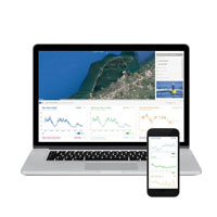
WQData LIVE is a web-based project management service that allows users 24/7 instant access to data collected from remote telemetry systems.


Hello
We are interested for measuring water incomes in rivers and channels from 150 l/s upto 30,000 l/s.
Can you suggest us your solutions like this one?
https://www.nexsens.com/blog/stream-river-monitoring-shoreside-data-logging.htm
Also, pls let me know price for them and your partner plan for lots of installations in Albania.
Thank you very much
Admirim