When the Francis Scott Key Bridge collapsed on March 26, 2024, NOAA was one of the first groups contacted as the city of Baltimore sought to minimize impacts to transport on the Patapsco River. As salvage efforts progressed in early April, real-time tidal currents data became necessary to help ensure safe navigation through the collapse site and to inform cleanup efforts.
In response, NOAA’s Center for Operational Oceanographic Products and Services (CO-OPS) deployed a current monitoring buoy—CURBY (Currents Real-time BuoY)—north of the bridge.
Challenges: Deploying an Effective Current Monitoring System Under Emergency Conditions
Katie Kirk, Robert Heitsenrether, and Lorraine Heilman were all part of the team that deployed the CURBY buoy in the wake of the Francis Scott Key Bridge Collapse. While the system has been deployed a number of times in different rivers, the rapidly changing environment of an emergency deployment presented new challenges.
Because the buoy had to be deployed in a matter of days, much of the paperwork that usually takes months to complete had to be expedited. Additionally, the constantly changing deployment location made programming the buoy difficult. The team also faced challenges with an unfamiliar launch site, boat ramp, and inclement weather conditions.
Kirk explains, “The buoy changing locations could potentially affect how the current meter was configured, and it could affect the mooring length depending on the total water depth.”
Heilman adds, “In order to actually ensure functional real time data, we were changing a lot parameters on the fly as the buoy was being installed. Those of us back on land also played our part in making sure the buoy was operational, and specifically making sure there was real-time data coming through.”
Solution: CO-OPS’ Currents Real-time BuoY
 Originally developed by CO-OPS’s Engineering Division, the CURBY buoy has been deployed in a number of rivers since its initial construction in 2018. Heitsenrether, a member of CO-OPS’s Engineering Division, led the team that designed, constructed, and tested the original CURBY buoy.
Kirk, an Oceanographer in CO-OPS, led the first project in the Delaware Bay and River that utilized the CURBY buoy in support of NOAA’s tidal current survey. Satisfied with the results of the real-time system, NOAA went on to build several more CURBY buoys for deployment in other waterways and projects, including the Columbia River led by Heilman and the Savannah River led by CO-OPS colleague Carl Kammerer. When not deployed, these buoys are on standby for quick deployment.
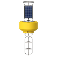
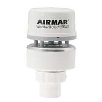
The first design of the CURBY system consisted of a single CB-950 equipped with an Airmar WX200, Nortek Acoustic Doppler Current Profiler (ADCP), Hach\Hydromet Sutron data logger, and satellite transmitter. However, more recent renditions of the CURBY feature a Gill GMX560 in place of the Airmar, and an In-Situ Aquatroll 200 sensor to measure water conductivity and temperature (CTD) in replacement of the larger SeaBird CTD.
Benefits: Real-Time Navigational Support after the Francis Scott Key Bridge Collapse
One of the reasons the CURBY buoy was chosen for the Francis Scott Key Bridge collapse response was the fact that the system was already assembled and ready for deployment , meaning that there was little delay in transporting the CURBY monitoring system that was deployed in the Patapsco River.
 With the ready-to-deploy CURBY system positioned at the CO-OPS Chesapeake, VA field office, NOAA was able to quickly prepare the buoy for deployment and get it stationed in Baltimore only days later.
Despite the unfamiliar deployment conditions, the system was successfully deployed, and the CURBY buoy was moored in position by NOAA’s 25-foot vessel R/V Tornado.
The Bottom Line
The goal of this project was to provide real-time data to the public and recovery partners as soon as possible following the buoy’s deployment. Fortunately, since its deployment, current data has been available online to the public, supporting navigational and cleanup efforts near the collapse.
The CB-950 was removed on 9/25/24 after 6 months of providing navigational aid on the river.
Equipment
The NexSens CB-950 Data Buoy is designed for deployment in lakes, rivers, coastal waters, harbors, estuaries and other freshwater or marine environments.
The Airmar 200WX is a compact weather station ideal for moving platforms. The sensor outputs apparent and true wind, barometric pressure, air temperature, GPS location, and more.
The MaxiMet Marine Compact Sensors combine IP68 environmental protection with high quality sensors for deployment on data buoys and in other marine environments.


