
 The Tom Ridge Environmental Center is located at the entrance to Presque Isle State Park in Erie, Penn. TREC is open year-round, offering visitors insight to what they can expect at Presque Isle State Park and the surrounding Great Lakes Region. TREC also serves as a center for research, contributing to conservation efforts, promoting environmental awareness, and helping to preserve the unparalleled beauty of Presque Isle.
The Regional Science Consortium is one of the many educational and research organizations establishing itself at the center. The collaborative, non-profit consortium coordinates educational and research projects for Lake Erie and the upper Ohio River Basin.
The consortium’s objective is to have all branches of science working in collaboration to exchange expertise, equipment, and ideas while sharing researchers and students as well. One of the consortium’s most recent research tools is a multi-parameter weather network that utilizes NexSens data loggers.
New tools for monitoring
 Two site locations were selected within the park. The first weather station was installed near Presque Isle’s Lake Erie shoreline, while a second was placed on top of the TREC’s 75-foot-tall glass tower.
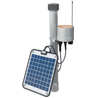
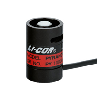
Researchers at the consortium selected the Vaisala WXT510 multi-parameter weather transmitter to measure six important weather parameters at each site. This unit simultaneously measures wind speed and direction, liquid precipitation, barometric pressure, temperature, and relative humidity. Complementing the Vaisala weather sensor is a global solar radiation sensor.
Both the Vaisala WXT510 weather transmitter and the pyranometer feature a plug-and-play interface to NexSens real-time data logging systems. Furthermore, the complete data logging and sensor system package is conveniently mounted on a two-foot mast.
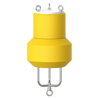
In 2008, the Regional Science Consortium added a NexSens MB-300 (legacy model) water quality data buoy to its real-time monitoring network. Securely housed within the buoy is a YSI 6920 V2-2 multi-parameter water quality sonde that samples for temperature, conductivity, pH, dissolved oxygen, and turbidity. The real-time water quality buoy is a valuable supplement for researchers, who previously had to collect manual grab samples to test for these parameters.
At user-specified intervals throughout the day, water quality and weather data is logged by the NexSens data loggers and sent via radio telemetry to a radio base station within the center. There, NexSens iChart software collects the data and automatically posts it to NexSens’ web datacenter, WQData. This provides virtually unlimited access to consortium members throughout the United States for use in their research or to determine water quality and weather conditions remotely for planning sampling trips at Presque Isle.
The weather and water quality data augments a predictive model for the determination of E. coli contamination on the beaches of Presque Isle. It is part of a complex system that provides information for making decisions regarding beach advisories and restrictions to swimming.
The CB-50 data buoy is designed for quick deployment in emergency response situations including industrial spills and natural disasters.
The NexSens X2 Environmental Data Logger offers the latest in real-time monitoring technology with wireless communication, large plug-and-play sensor library, and ultra-low power consumption.
The YSI EXO3 is a purpose-built sonde for monitoring major water quality parameters, including: pH, conductivity, temperature, turbidity and dissolved oxygen.
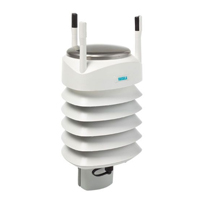
The Vaisala WXT536 Multi-Parameter Weather Sensor simultaneously measures air temperature, humidity, pressure, rainfall and wind in a compact platform with optional heating.
The LI‑200R Pyranometer measures total solar radiation. In outdoor sky conditions, the LI‑200R performs comparably to first-class thermopile pyranometers.

WQData LIVE is a web-based project management service that allows users 24/7 instant access to data collected from remote telemetry systems.