
 Located in southwest Ohio, Buck Creek and its tributary, Beaver Creek, run through a series of low-head dams in the city of Springfield. Historically, the four dams diverted water for mills and local industry and protected utilities along a continuous four-mile reach. However, they’ve also interfered with the water’s natural flow and inhibited stream health.
The Springfield Conservancy District and Friends of the Buck Creek Recreation Corridor are working to restore a more natural flow to the creek while maintaining the benefits provided by the dams. Though planned changes to the dams are primarily for recreational purposes, they will help restore the flow of sediments and fish, as well as provide a healthier ecosystem for Buck Creek. Approved by the U.S. Army Corps of Engineers, removal of one of the low-head dams and modification of another began in the fall of 2009.
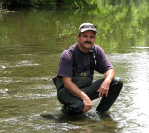
Many precautions have been taken to observe and address concerns regarding flood hazards, wetland soils, endangered species, historic properties and sites, combined sewer overflows, and stream integrity. Dr. John Ritter, professor of geology at nearby Wittenberg University, has been studying the project’s impacts on Buck Creek’s ecosystem.
NexSens Technology worked with Ritter to set up a comprehensive monitoring network, which includes a rooftop weather station, stream gauge station, and four water quality monitoring stations, to help automate sampling efforts. The monitoring tools implemented at Buck Creek allow researchers at Wittenberg to monitor weather, stream flow, and water quality data as it occurs, helping to facilitate safe dam removal and assess the impact of the stream restoration.
Monitoring ecosystem impacts in real time
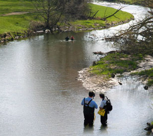
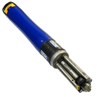
 The four water quality stations are positioned upstream and downstream of the reach where the low-head dams are located, and they help assess how changes to the dams affect water quality. Each station is outfitted with a YSI 6920 V2-2 multi-parameter sonde that measures temperature, conductivity, pH, dissolved oxygen, and turbidity.
An upstream monitoring site by Beaver Creek, which is also equipped with a water level sensor, uses cellular telemetry to send data back to the university. Another water quality station is located near the Springfield Museum of Art. This station lies immediately downstream of several significant combined sewer overflows that impact water quality.
A stream gauge station is housed at a gage house formerly managed by the U.S. Geological Survey. It employs a NexSens AccuStage vented water level sensor, providing data that will eventually be converted to stream discharge. The sensor is fixed in a stilling well below the minimum expected water level, and a cable containing the sensor signals and vent tube runs from the sensor to a NexSens radio telemetry data logger.
Farther downstream, monitoring equipment is mounted under a bridge and uses spread-spectrum radio telemetry to transmit data to the project computer.
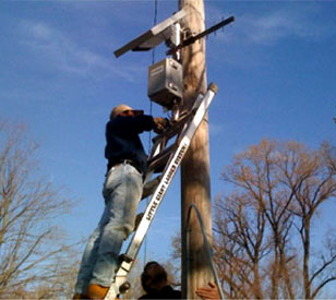
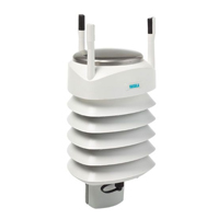
Located on the roof of the Wittenberg lab building is a multi-parameter weather station. The weather station is multi-functional: it collects weather data locally from a multi-parameter weather sensor, but it also serves as a radio signal repeater from the remote sites into the Wittenberg lab. The station employs a Vaisala WXT-series, which is a unique multiparameter weather sensor that simultaneously measures wind speed and direction, liquid precipitation, barometric pressure, temperature, and relative humidity.
The remote monitoring sites integrate with one another to form a reliable network for streaming environmental data into Wittenberg’s Barbara Deer Kuss Science Center. In the geology lab, NexSens iChart software serves as the centralized database and control center for the remote network.
iChart is also set to automatically relay incoming data to a NexSens WQData website. WQData is a secure Web datacenter hosted by NexSens Technology that provides an online interface for viewing environmental data. It offers 24/7 instant access to project data. This Web-based interface allows researchers at Wittenberg and other interested parties to view current and past conditions of Buck Creek from any Internet browser.
Customer Testimonial
 “NexSens Technology has been extremely responsive to our needs. From the initial design of the monitoring to actual setup, they offered advice, creative solutions, and timely support to the project. The upstream site, with both banks in bedrock, is unique in their experience. The design they developed for anchoring the water quality sonde is stable and secure and does not detract from the natural setting.
I appreciated their help and advice both in design and installation support. There were a lot of decisions that needed to be made on the spot, and I appreciated their ability to troubleshoot and make those decisions. The team’s patience in the installation, not leaving until things were working right and guiding me through the use of the software, is a hallmark for how NexSens treats their customers. And the support did not end there. The NexSens support team recently guided us through the calibration process of our YSI water quality sondes, making certain a student assistant and I were comfortable with the process and offering tips and suggestions to ensure the quality of the data.”
— Dr. John Ritter, Professor of Geology

The X2-SDL Submersible Data Logger is a rugged, self-powered data logging system with optional cellular, satellite, or radio communications.
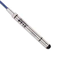
Designed to resist the elements, the Seametrics PT12 delivers accurate pressure and temperature readings in rugged environments.
The YSI EXO represents the next generation of water quality instruments from YSI. The EXO2 sonde includes six sensor ports and a central anti-fouling wiper option.
The Vaisala WXT536 Multi-Parameter Weather Sensor simultaneously measures air temperature, humidity, pressure, rainfall and wind in a compact platform with optional heating.

WQData LIVE is a web-based project management service that allows users 24/7 instant access to data collected from remote telemetry systems.